The Calculus of Discovery
In the annals of human exploration, the Heroic Age of Polar Exploration stands as a unique era where physical endurance was inextricably linked to mathematical precision. To the modern observer, accustomed to the instantaneous certainty of GPS and satellite imagery, the challenges faced by pioneers like Roald Amundsen, Robert Falcon Scott, and Robert Peary can seem almost incomprehensible. These men were not merely athletes or adventurers; they were forensic navigators who operated in a world where "truth" was a variable that had to be solved using brass instruments, the movement of the stars, and the steady hand of a calculator working in sub-zero temperatures.
This article explores the rigorous "audit of discovery" that defined the era. It moves beyond the familiar stories of frostbite and tragedy to examine the "Science of Truth" - the specific methods and tools used to turn a featureless white void into a verifiable point on the globe. From the mercury-filled troughs used to capture a fake horizon to the meticulously recorded boiling points of water used to map the vertical ascent of a continent, the verification of the poles was a masterpiece of 19th-century engineering. It is a story of how human integrity stood trial before the laws of celestial mechanics, and how a handful of coffee-stained journals became the final, undeniable evidence of the furthest reaches of the Earth.
The Problem of the Featureless Horizon
The pursuit of the geographic poles in the late 19th and early 20th centuries presented a unique scientific paradox: how does a traveler prove they have reached a destination that possesses no physical markers, no unique topography, and no permanent landmarks? Unlike a mountain climber who can stand upon a specific peak or a sailor who can identify a coastline, a polar explorer at the turn of the century found themselves atop a shifting, monochromatic wasteland. At the South Pole, the environment was a high-altitude ice plateau nearly 10,000 feet thick, while the North Pole consisted of nothing but drifting pack ice over a deep ocean. In both cases, the horizon at 90 degrees latitude looks identical to the horizon at 88 degrees. Consequently, the Pole was not a place one could see; it was a mathematical coordinate that had to be calculated into existence through rigorous observation.
This lack of visual evidence created an environment where the burden of proof rested entirely on the integrity of the traveler’s data. During this era, the global scientific community and the public were increasingly wary of fraudulent claims. The most famous example of this skepticism arose during the 1909 controversy between Americans Robert Peary and Frederick Cook. Both men claimed to have reached the North Pole, yet neither could provide the kind of undeniable physical evidence that would satisfy a panel of experts. Cook’s claim was eventually dismissed largely because his navigation logs were "too perfect," lacking the messy, raw calculations and daily errors that naturally occur during a harrowing journey through sub-zero winds. Peary’s claim, while more widely accepted at the time, has faced over a century of scrutiny because he lacked a second, independent navigator to verify his final sightings.
The Hardware of Truth: Instruments of the Heroic Age
To translate the abstract concept of a geographic coordinate into a verifiable reality, the explorers of the Heroic Age carried a suite of analog instruments that served as their only connection to the wider world. These tools were far more than mere conveniences; they were survival-critical computers that allowed a navigator to determine their position on a sphere by observing the stars and the sun. The most vital of these was the sextant, a device designed to measure the angular distance between a celestial body and the horizon. However, the polar environment presented a unique challenge: the lack of a reliable sea-level horizon. On the massive, undulating ice plateau of Antarctica, the horizon was often obscured by ground drift or distorted by the curvature of the ice. To solve this, navigators used an artificial horizon, which consisted of a small trough filled with liquid mercury. By measuring the angle between the real sun and its perfect reflection in the mercury, the explorer could calculate the sun's true altitude with remarkable precision.
Equally critical to the mission was the chronometer, a highly accurate mechanical watch designed to keep "civil time" even in the most extreme conditions. While latitude could be found by measuring the height of the sun at noon, determining longitude required knowing exactly what time it was at a fixed reference point, such as Greenwich, England. To prevent a catastrophe where the team might lose their East-West orientation, expeditions often carried multiple chronometers, comparing them daily to ensure that none had developed a "drift" in their timing. This obsession with time-keeping meant that every calculation recorded in a field journal was inextricably linked to a specific second of the day, creating a chronological anchor that made it nearly impossible to fabricate a journey after the fact.
Celestial Mechanics and the Geometry of the Axis
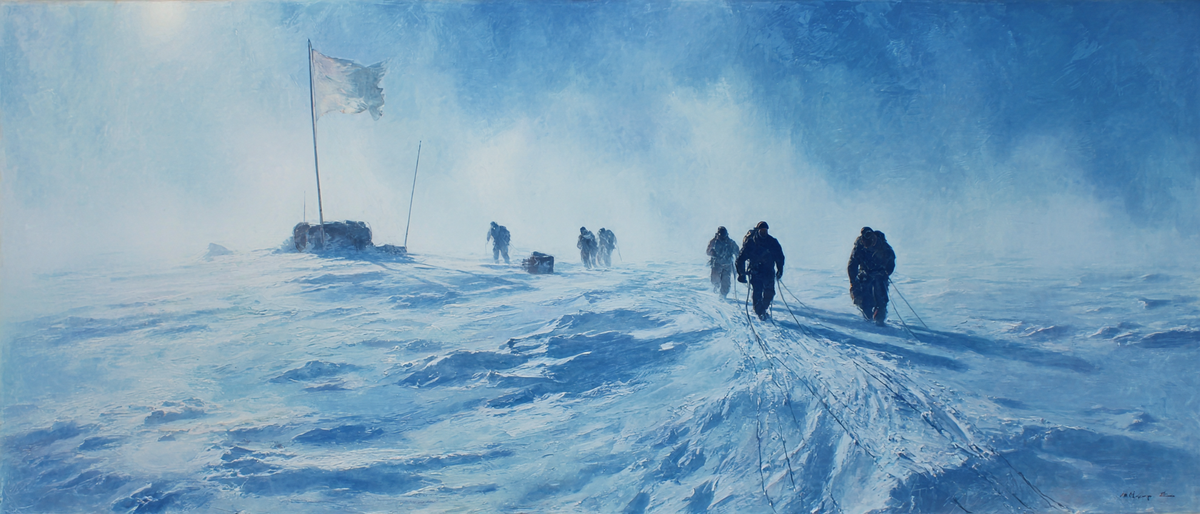
The most profound proof of arrival at the terrestrial pole lies in the unique behavior of the sun as it relates to the Earth's axis. Under normal circumstances at lower latitudes, the sun rises and sets at varying angles, reaching its zenith at midday before descending. However, as an explorer nears the geographic pole, the arc of the sun flattens until it eventually moves in a perfect, level circle around the sky, never changing its altitude over a twenty-four-hour period. To prove he had reached 90° South in December 1911, Roald Amundsen utilized this phenomenon by staying at the site for three days. His team took sextant readings every hour, documenting that the sun remained at a constant height regardless of the time. This Solar Circle provided an undeniable mathematical signature; if the team had been even a few miles away from the true axis, the sun would have appeared slightly higher at noon and lower at midnight.
To safeguard against instrument drift or atmospheric refraction - the bending of light as it passes through cold air - Amundsen employed a tactical verification method known as "boxing the pole." Upon reaching the estimated coordinate, he dispatched three members of his team in different directions for a distance of roughly ten miles. Each man erected a dark flag on a bamboo pole, effectively creating a massive physical triangle that encircled the calculated center. This maneuver ensured that the true Geographic South Pole was guaranteed to be trapped within the perimeter created by his men, providing a margin of physical certainty that transcended the limitations of his lenses.
The Vertical Benchmark: Hypsometry and Altitude
While celestial navigation confirmed a horizontal position, explorers also had to verify their vertical position to ensure their data aligned with the known geography of the polar regions. The South Pole is located atop a massive ice dome nearly two miles above sea level. To prove they had reached this specific environment, expeditions utilized hypsometry, the science of measuring altitude through the boiling point of water. Because atmospheric pressure decreases as one ascends, water boils at lower temperatures at higher elevations. By recording the exact temperature at which their Primus stoves brought water to a boil, explorers could calculate their altitude to within a few hundred feet. This provided a geographical fingerprint that was nearly impossible to forge, as the recorded boiling points had to correspond perfectly with the barometric pressure readings taken at the coast by their base teams.
The Navigator’s Challenge and the Problem of Drift
A significant hurdle for any explorer was the dynamic nature of the ice itself. While the South Pole rests on a grounded continental mass, the North Pole is situated on a shifting pack of sea ice in constant motion. This created a phenomenon known as the treadmill effect, where a team might march south for twelve hours only to find that the ice had drifted north by several miles during that same period. To account for this, navigators had to perform a complex logic puzzle every time they took a solar sighting. If the distance recorded by the sledge-meter did not match the change in latitude recorded by the sextant, the navigator had to determine if the error lay in a mechanical failure of the wheel or in the movement of the Earth beneath their feet. The sun’s timing relative to their chronometers was the only way to solve this riddle, transforming the explorer into a forensic mathematician.
The Integrity of the Coffee-Stained Journal
The ultimate verification of a polar expedition occurred in the quiet, wood-paneled halls of scientific societies. When an explorer returned, they were required to surrender their original field notebooks for an examination that could last months. These journals were treated as legal evidence. Experts looked for internal consistency - a state where every data point aligned with the laws of physics. A journal that was too clean was immediately suspected of being a "fair copy" written after the fact, whereas a true field record was expected to be stained with paraffin, marked by frozen fingers, and filled with the messy scratch-work of daily calculations. Modern forensic science has added a final layer through shadow-graphy: by measuring the height of an explorer in a photo and the length of their shadow, historians can determine the sun's altitude at that precise moment. If an explorer claimed to be at the Pole, but their shadow is too long for that specific date and time, the light itself exposes the lie.
The Final Witness
The history of these expeditions teaches us that the truth of an achievement is a mosaic of data points. When Robert Falcon Scott reached the South Pole in January 1912, the sight of Amundsen’s tent was a crushing blow, yet it served as the most perfect scientific verification possible. Scott’s subsequent navigation confirmed that Amundsen had pinpointed the axis with incredible accuracy. This unintentional audit by a competitor provided a level of proof that no single expedition could achieve on its own. Today, these coffee-stained journals remain as a testament to human integrity, reminding us that during the Heroic Age, the map was built - one calculation at a time - by men who understood that to lead the world to a new place, they first had to prove exactly where they stood.
The "Witness" Document: A Real Log Excerpt
It is worth looking at the actual "Proof of the Pole" as written by Roald Amundsen on December 14, 1911. While his prose was simple, the math behind it was his shield against history:
"At twelve o’clock, midday, we reached our goal. We had previously, on several occasions, taken altitudes of the sun, and found that we were as near to the Pole as our instruments could determine. We have now been here for three days... and during this time we have taken a series of observations which show that we are exactly at the Geographic South Pole."
Amundsen’s "series of observations" consisted of hourly sextant readings for 72 consecutive hours. This raw data remains in the archives of the National Library of Norway, a permanent record of a destination reached through the mastery of the stars.
Suggestions for Further Reading
Primary Accounts and Journals
- The South Pole
- Author: Roald Amundsen
- Recommended Edition: Skyhorse Publishing (Modern Reprint) or John Murray (Original Publisher, 1912).
- Scott’s Last Expedition: The Journals
- Author: Robert Falcon Scott
- Recommended Edition: Oxford World's Classics (Oxford University Press). This edition is highly valued for its extensive footnotes and historical context.
Modern Historical Analysis
- The Last Place on Earth (Originally published as Scott and Amundsen)
- Author: Roland Huntford
- Publisher: Modern Library (Random House).
- The Expedition: Solving the Mystery of a Polar Tragedy
- Author: Bea Uusma
- Publisher: Head of Zeus (UK) or Fourth Estate (Australia/International).
- Ninety Degrees North: The Quest for the North Pole
- Author: Fergus Fleming
- Publisher: Grove Press (Granta Books in the UK).
Technical and Scientific Context
- The Coldest March: Scott's Fatal Antarctic Expedition
- Author: Susan Solomon
- Publisher: Yale University Press.
- To the Ends of the Earth: The Transglobe Expedition
- Author: Ranulph Fiennes
- Publisher: Hodder & Stoughton.
Member discussion: